
MAPS

OVERVIEW
Grand View Canyon is the crown jewel of Saline Valley being a beautiful but challenging canyon containing spectacular polished narrows and a spur trail leading to perhaps Death Valley's largest arch. Difficulties encountered on the hike include having the proper HC or 4WD vehicle to drive to the starting point, route finding to access the canyon, and getting past a progressively more difficult series of four obstacles in the lower canyon. A Google Earth map of the hiking route can be found by clicking on the button above. GPS coordinates for the parking area are 36° 52.497'N, 117° 41.643'W. GPS coordinates for the mouth of Grand View Canyon are 36° 52.375'N, 117° 39.457'W. GPS coordinates for the 1st obstacle are 36° 52.434'N, 117° 38.675'W.
OUR VISIT
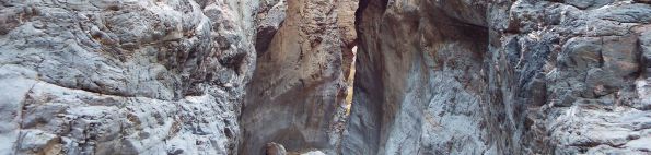
Grand View Canyon is the most spectacular canyon in the Last Chance Range and one of the most beautiful canyons in Death Valley. I first learned about Grand View Canyon when I was researching Death Valley's natural bridges and a formation in the area was brought to my attention. Lizard Lee, the hard working and helpful camp host at the Saline Valley warm springs happened to read my special database on Death Valley's Natural Bridges. Reading the database reminded him of an arch that he had discovered many years ago out in Grand View Canyon. Thus, he was kind enough to let me know about it. When it comes to Saline Valley, it is common knowledge that there are a lot of well-kept secrets out in the area. I am aware of a few of the secrets, but do my part to keep them under wraps and minimize visitation to the area out of respect for regular visitors to the springs. So I was very grateful when Lizard Lee was willing to let me know about Grand View Canyon and the amazing arch that is found out there. As far as Grand View Canyon, that is a name that has been assigned to the canyon by Saline Valley regulars. The canyon also has an alternate name of Saline Rainbow Canyon. But since there is already a Rainbow Canyon in the park, I decided that it was better to promote the Grand View Canyon name. Besides, that name is very fitting, as you will see in my pictures down below. Getting back to the canyon itself, I was informed that it was known for two features-- the gigantic arch and the endless narrows. As I did my research on Google Earth, I was eventually able to locate the arch above the canyon. I also studied the narrows extensively and came to the conclusion that there were at least 3 potential major obstacles in the canyon.
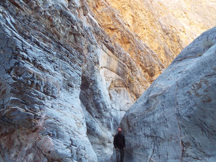
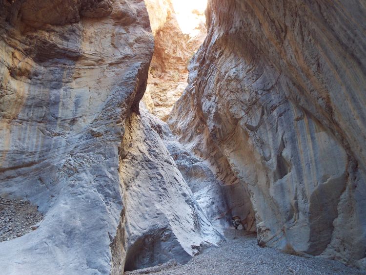
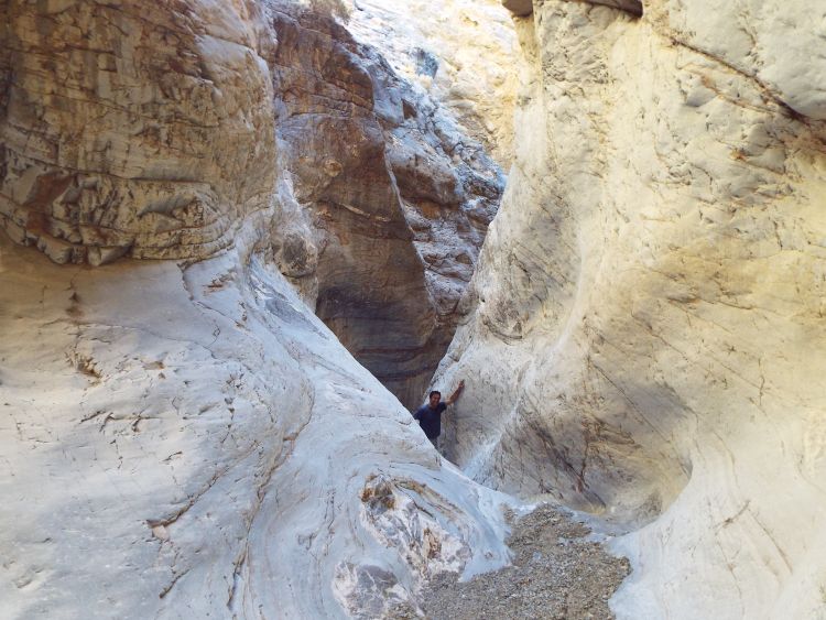
After months of planning, November of 2013 finally rolled around and it was time for our trip. And that brings us to the biggest obstacle of all in hiking the canyon-- how to get there. The mouth of Grand View Canyon is located about 8 miles or so past the Saline Valley warm springs. Extensive flooding in the late summer of 2013 had brought havoc to the roads in the park, including those in Saline Valley. The two roads which led to the starting point for the hike were listed as washed out and impassable. Thus, we picked up a Jeep rental from Farabee's and drove up Dedeckera Canyon and over Steel Pass until we reached the parking area. After setting up camp for the night, we started our hike at 5:30am the next morning. It was about 1 1/2 miles from the parking area (2,800 ft) to the mouth of the canyon (3,400 ft). Once we reached the canyon mouth, we put our headlamps away and turned back to watch the sunrise reflecting off the Inyo Mountains. Through the early part of Grand View Canyon, we could tell that we were in a special place. The colors were vibrant and the scenery was interesting. For the next 1 1/2 miles, we gained another 700 feet in elevation. And then we reached the first obstacle. I was not expecting this obstacle, so it caught me off guard. The obstacle was essentially a junction, with narrows to the left and narrows to the right. The narrows to the left looked easier (and more spectacular), so we turned that way. The narrows to the left turned out to be filled with plants and were very impressive. But after a short distance, they dead-ended at a large dry fall with no potential bypasses. Thus, we returned to the main canyon and tried the right option. The right narrows were a series of steep, polished dry falls. A couple of these were almost too high for us to climb. I wondered how we would get back down them later, but pushed on because of the anticipation of seeing the rest of the canyon. Eventually, we got past the dry cascades and emerged back into a large canyon wash. It turned out that we had chosen the correct route (right at the junction) and were continuing up Grand View Canyon. Off to the left, I spotted the faint trail leading up to Grand View Arch. (To read more about that steep side trip with exposed cliffs on one side, please see my report for Grand View Arch.) Upon returning to the canyon from our side trip to Grand View Arch over an hour later, we continued hiking and soon reached the 2nd Narrows. The 2nd Narrows were absolutely incredible. After hiking through (most of) the 2nd Narrows, I decided that Grand View Canyon would properly be classified as 1 of my 4 favorite canyons in the park, along with Moonlight Canyon, Big Fall Canyon, and Hidden Bridge Canyon. However, just like those 3 other canyons, Grand View would also deny me the opportunity to see the entire canyon in one day. Moonlight took me 2 days, Big Fall took me 2 days, and Hidden Bridge had taken me 3 days. The reason why it took so long to see those canyons is the presence of obstacles in the canyons. And Grand View Canyon had obstacles as well. The first obstacle had been challenging enough, but about halfway through the 2nd Narrows, we ran into more. Just before reaching those obstacles, we were treated to two very special sights in the canyon. First, I managed to spot a stunning double arch high up on the canyon wall. This double arch is only visible from perhaps two spots in the entire canyon. This is because of the height of the narrows blocking views of the canyon walls high above. I only managed to spot the double arch due to waiting for Mel in one spot for about 10 minutes. Just past the double arch viewpoint, we found two massive boulders wedged above us in some tight narrows. It was a bit reminiscent of Lower Foundry Canyon. And then came the second obstacle. The second obstacle was a tall polished dry fall with no handholds. Previous hikers had stacked rocks in an attempt to get a boost up the dry fall. I managed to get up the dry fall and then extend a hand to help Mel get up it as well. But it wasn't easy and more than a few hikers will have to turn around at this obstacle in order to maintain proper safety. Just beyond was the third obstacle, another dry fall where height can give you an advantage in getting up. After getting through that, we enjoyed some of the nicest parts of the 2nd Narrows. In my trip planning, I hadn't expected to be able to get all the way through the 2nd Narrows. And I turned out to be right. At what seemed to be the very end of the 2nd Narrows, we encountered a fourth obstacle, which was a giant boulder jam. There was no safe way to get past it, so we turned around and hiked back out of the canyon. On my maps, I had marked a potential one-mile bypass using a long ridge and some sheep trails, but we decided to save that for another trip. We had already seen a lot of amazing sights on our hike and it seemed wise to divide Grand View Canyon into three separate hikes -- Lower Grand View Canyon (today's hike), Middle Grand View Canyon (using my one-mile potential bypass), and Upper Grand View Canyon (coming in from the top by way of Round Valley). On the way out, I had to face my fears as we stood at the top of the hardest dry fall in the 1st Narrows. It was then that I spotted a short bypass to my left (or to the right when heading up canyon). The bypass seemed to be much easier than the dry fall, although Mel went down the dry fall. I quickly took the bypass down and met up with him a couple of minutes later, and then we hiked back to our vehicle. This bypass might help hikers avoid the first obstacle and reach the 2nd Narrows, if hikers deem it to be safely within their own comfort level. Although we drove in Dedeckera Canyon and Steel Pass, we ended up driving out Saline Valley Road and South Pass. The main reason was so that we could stop by the springs and thank Lizard Lee for the outstanding hike. While there, we noticed that the Sunrise Pool was empty, so we put on our swim trunks and soaked for a while, which went a long way towards helping us recover from the epic hike. Our hike took place on November 13, 2013.
After months of planning, November of 2013 finally rolled around and it was time for our trip. And that brings us to the biggest obstacle of all in hiking the canyon-- how to get there. The mouth of Grand View Canyon is located about 8 miles or so past the Saline Valley warm springs. Extensive flooding in the late summer of 2013 had brought havoc to the roads in the park, including those in Saline Valley. The two roads which led to the starting point for the hike were listed as washed out and impassable. Thus, we picked up a Jeep rental from Farabee's and drove up Dedeckera Canyon and over Steel Pass until we reached the parking area. After setting up camp for the night, we started our hike at 5:30am the next morning. It was about 1 1/2 miles from the parking area (2,800 ft) to the mouth of the canyon (3,400 ft). Once we reached the canyon mouth, we put our headlamps away and turned back to watch the sunrise reflecting off the Inyo Mountains. Through the early part of Grand View Canyon, we could tell that we were in a special place. The colors were vibrant and the scenery was interesting. For the next 1 1/2 miles, we gained another 700 feet in elevation. And then we reached the first obstacle. I was not expecting this obstacle, so it caught me off guard. The obstacle was essentially a junction, with narrows to the left and narrows to the right. The narrows to the left looked easier (and more spectacular), so we turned that way. The narrows to the left turned out to be filled with plants and were very impressive. But after a short distance, they dead-ended at a large dry fall with no potential bypasses. Thus, we returned to the main canyon and tried the right option. The right narrows were a series of steep, polished dry falls. A couple of these were almost too high for us to climb. I wondered how we would get back down them later, but pushed on because of the anticipation of seeing the rest of the canyon. Eventually, we got past the dry cascades and emerged back into a large canyon wash. It turned out that we had chosen the correct route (right at the junction) and were continuing up Grand View Canyon. Off to the left, I spotted the faint trail leading up to Grand View Arch. (To read more about that steep side trip with exposed cliffs on one side, please see my report for Grand View Arch.) Upon returning to the canyon from our side trip to Grand View Arch over an hour later, we continued hiking and soon reached the 2nd Narrows. The 2nd Narrows were absolutely incredible. After hiking through (most of) the 2nd Narrows, I decided that Grand View Canyon would properly be classified as 1 of my 4 favorite canyons in the park, along with Moonlight Canyon, Big Fall Canyon, and Hidden Bridge Canyon. However, just like those 3 other canyons, Grand View would also deny me the opportunity to see the entire canyon in one day. Moonlight took me 2 days, Big Fall took me 2 days, and Hidden Bridge had taken me 3 days. The reason why it took so long to see those canyons is the presence of obstacles in the canyons. And Grand View Canyon had obstacles as well. The first obstacle had been challenging enough, but about halfway through the 2nd Narrows, we ran into more. Just before reaching those obstacles, we were treated to two very special sights in the canyon. First, I managed to spot a stunning double arch high up on the canyon wall. This double arch is only visible from perhaps two spots in the entire canyon. This is because of the height of the narrows blocking views of the canyon walls high above. I only managed to spot the double arch due to waiting for Mel in one spot for about 10 minutes. Just past the double arch viewpoint, we found two massive boulders wedged above us in some tight narrows. It was a bit reminiscent of Lower Foundry Canyon. And then came the second obstacle. The second obstacle was a tall polished dry fall with no handholds. Previous hikers had stacked rocks in an attempt to get a boost up the dry fall. I managed to get up the dry fall and then extend a hand to help Mel get up it as well. But it wasn't easy and more than a few hikers will have to turn around at this obstacle in order to maintain proper safety. Just beyond was the third obstacle, another dry fall where height can give you an advantage in getting up. After getting through that, we enjoyed some of the nicest parts of the 2nd Narrows. In my trip planning, I hadn't expected to be able to get all the way through the 2nd Narrows. And I turned out to be right. At what seemed to be the very end of the 2nd Narrows, we encountered a fourth obstacle, which was a giant boulder jam. There was no safe way to get past it, so we turned around and hiked back out of the canyon. On my maps, I had marked a potential one-mile bypass using a long ridge and some sheep trails, but we decided to save that for another trip. We had already seen a lot of amazing sights on our hike and it seemed wise to divide Grand View Canyon into three separate hikes -- Lower Grand View Canyon (today's hike), Middle Grand View Canyon (using my one-mile potential bypass), and Upper Grand View Canyon (coming in from the top by way of Round Valley). On the way out, I had to face my fears as we stood at the top of the hardest dry fall in the 1st Narrows. It was then that I spotted a short bypass to my left (or to the right when heading up canyon). The bypass seemed to be much easier than the dry fall, although Mel went down the dry fall. I quickly took the bypass down and met up with him a couple of minutes later, and then we hiked back to our vehicle. This bypass might help hikers avoid the first obstacle and reach the 2nd Narrows, if hikers deem it to be safely within their own comfort level. Although we drove in Dedeckera Canyon and Steel Pass, we ended up driving out Saline Valley Road and South Pass. The main reason was so that we could stop by the springs and thank Lizard Lee for the outstanding hike. While there, we noticed that the Sunrise Pool was empty, so we put on our swim trunks and soaked for a while, which went a long way towards helping us recover from the epic hike. Our hike took place on November 13, 2013.
SAFETY ALERTS
This hike contains sections of climbing, exposed bypasses and/or high dry falls and may require safety ropes and equipment in order to complete the entire hike. Those without the proper training, experience, and safety gear should not try to climb any dry falls or obstacles encountered during the hike which feel unsafe or beyond personal abilities.

SAMPLE PHOTOS
ALL PHOTOS
Many more photographs taken during our visit are available for viewing for this destination. To see all of them, choose one of the two options presented below. The two options are Slideshow viewing and Trip Report viewing. The Slideshow option allows for viewing larger images with an autoplay option and a full screen option (available on most browsers). This option works very well for large computer screens and tablets. The Trip Report option allows for viewing smaller pictures in a standard scroll-down format and enlarging of any panoramic photos taken during our visit. Click on the option of your choice to view all of our photos from this destination. The Slideshow format opens in a new browser window and the Trip Report format uses the same browser window for viewing.
SLIDESHOW FORMAT
TRIP REPORT FORMAT