

OVERVIEW
The Plain of Six Glaciers trail is one of the best hikes in the Canadian Rockies as it begins at Lake Louise and climbs up a scenic valley overlooking the lake while passing by six massive glaciers. Difficulties encountered on the hike include dealing with a large amount of tourists since this hike is very popular, dealing with possible bear encounters along the trail, and finding a nice day with good visibility to do the hike. Route maps and GPS coordinates are not provided because this is an official trail which is maintained by Parks Canada. All hikers should obtain updated information on the hike and current conditions from the Banff Information Centre or the Lake Louise Visitor Centre.
OUR VISIT
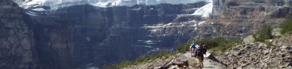
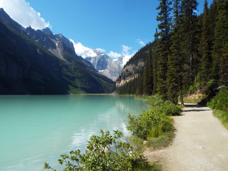
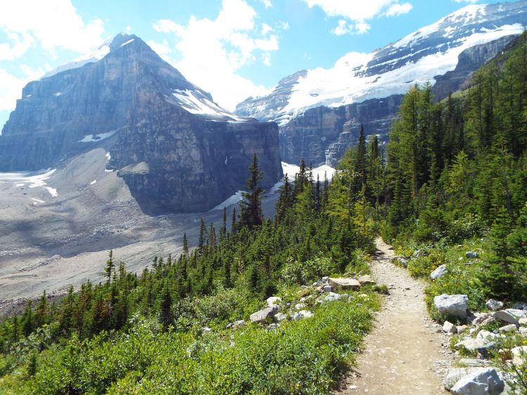
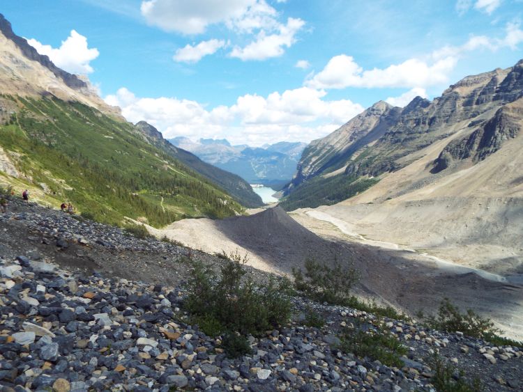
Our Canadian Rockies trip in the summer of 2013 kicked off with a two night stay at Lake Louise. As an introduction to the many outstanding hikes in the area, I decided to hike the legendary Plain of Six Glaciers Trail. Admittedly, the grand (and very expensive) hotel that we stayed at overlooking the lake detracts from the natural beauty of the area. But it did provide a couple of nice benefits. For one thing, the hotel provided us with free use of bear repellant pepper spray for the hike. I wasn't too concerned with needing it on the heavily-used Plain of Six Glaciers Trail, but rather for a somewhat secret spur trail which leads to the foot of Upper Victoria Glaicer we would be taking. Also, staying at the hotel allowed me to literally walk outside and begin the hike without having to drive in from another location and hassle with the parking mess which is present during the summer months. The Plain of Six Glaciers hike turned out to be outstanding for many reasons. The hike started at beautiful Lake Louise and began by wrapping around the right (or northern) side of the lake. This allowed plenty of time to take in various views of the stunning blue water of Lake Louise which has very few equals in the world. The obvious drawback was the mass amount of tourists doing this same walk. Because the first part of the hike is paved and level, Daria, Renee, and Stefan all joined us for this portion. Once we reached the opposite side of the lake, the trail began to gain elevation as it climbed through the forest while staying close to the glacial stream. Various views looking back at Lake Louise kept our attention. The crowds thinned down to about half of what they were down at Lake Louise, but that still meant there were a lot of fellow hikers. At this point, the actual plain that the hike is named for becomes visible in the form of what looks like a long gravel-filled valley. A closer inspection from farther up the trail reveals that The Plain is actually a glacier that has been covered by silt and gravel. Along with The Plain, you can begin to see some of the other Six Glaciers, the first of which is Aberdeen Glacier just below Mount Aberdeen. Next up is the sheer face of Mount Lefroy, near which is the Upper Lefroy Glacier and Lower Lefroy Glacier with The Mitre in the background. A short time later, we reached the tea house which further thinned out some of the crowds. Beyond the tea house, the trail crosses over a rocky wash filled with boulders for as far as you can see up the hillside to your right. If you use your eyes to follow the wash of boulders up and look towards the background peak, you can see Popes Glacier (the 4th of the 6 glaciers visible along the route) and Popes Peak. The only two glaciers left to see are Lower Victoria Glacier and Upper Victoria Glacier, but you have actually already seen glimpses of these from a distance on the hike up. Better views of both are just ahead. The trail ends at the 4.3 mile mark with a view of Abbot Pass (located in between Mount Victoria and Mount Lefroy) and The Death Trap which leads up to it. There is also a pretty glacial waterfall at this spot and excellent views looking back down the valley toward Lake Louise. While this was the end of the hike for virtually all other groups that day, our hike continued. Heading back toward the tea house, we turned off to the left just before reaching the side valley of boulders below Popes Peak and followed a relatively unknown spur trail which heads into the forest. The trail was very overgrown and obviously does not get a lot of use. The entire way up the trail, we never saw any signs of any other people. The solitude was amazing to have in such a beautiful location. As we climbed above the Plain of Six Glaciers Trail through steep terrain, the views were outstanding. The view of the western face of Popes Peak was notable. Our ultimate destination was the foot of Upper Victoria Glacier. After hiking through the forest, through an open area of boulders and rock, and along a ridge, we finally arrived there. Once again, amazing views were seen all around, as you can see in the pictures down below. The highlight of the hike came when we set foot on Upper Victoria Glacier, thus completing our hike of the Plain of Six Glaciers and the Upper Victoria Glacier spur trail. Our hike took place on August 9, 2013.
SAMPLE PHOTOS
ALL PHOTOS
Many more photographs taken during our visit are available for viewing for this destination. To see all of them, choose one of the two options presented below. The two options are Slideshow viewing and Trip Report viewing. The Slideshow option allows for viewing larger images with an autoplay option and a full screen option (available on most browsers). This option works very well for large computer screens and tablets. The Trip Report option allows for viewing smaller pictures in a standard scroll-down format and enlarging of any panoramic photos taken during our visit. Click on the option of your choice to view all of our photos from this destination. The Slideshow format opens in a new browser window and the Trip Report format uses the same browser window for viewing.
SLIDESHOW FORMAT
TRIP REPORT FORMAT